Okay, I had planned to do a different post this week as part of this month’s RPG blog carnival but that will have to wait. I decided instead to just push through and finish the Expanded Frontier Map instead.
Corrections
If you downloaded the color player’s map from last week’s post, go back and do it again. As I was working on the final map, I found a bunch of mistakes that I completely missed while working on last week’s map. Most of them are minor, like names overlapping jump lines, but a few of them are pretty bad like names overlapping each other or running over jump distances. In any case, I’ve fixed those and uploaded new maps to the links in that article.
Adding the Sathar
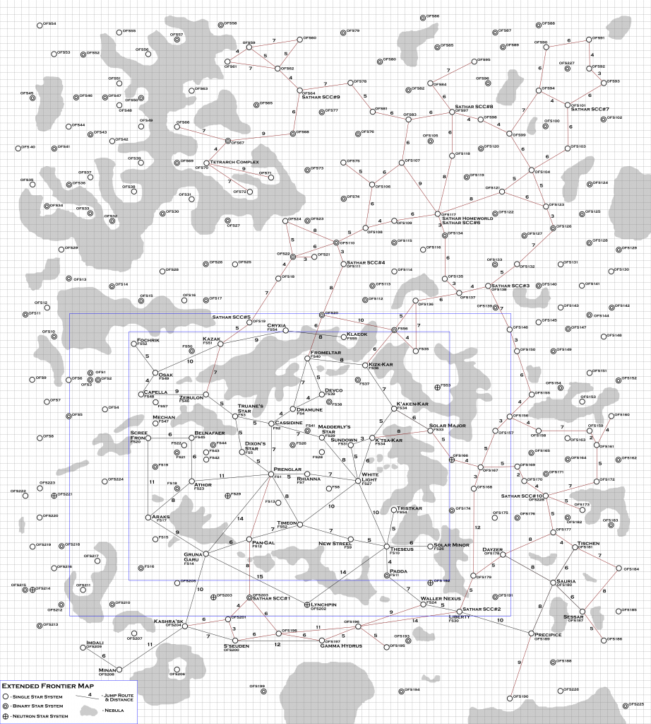
The only difference between this map and the previous one is that I’ve added in all the jump routes known by the sathar as well as some labels on the map that give the location of the sathar homeworld, their ten starship construction centers, and the location of their Tetrarch ruins complex similar to the one on Laco (If you are following the timeline posts, this is where the signal went out to and was returned from). I haven’t defined which of these systems are actually inhabited by sathar, I’m leaving that up to the individual referee to decide.
Let’s start by showing the black and white version of the map and then I’ll talk about how I filled it in.

Jump Routes
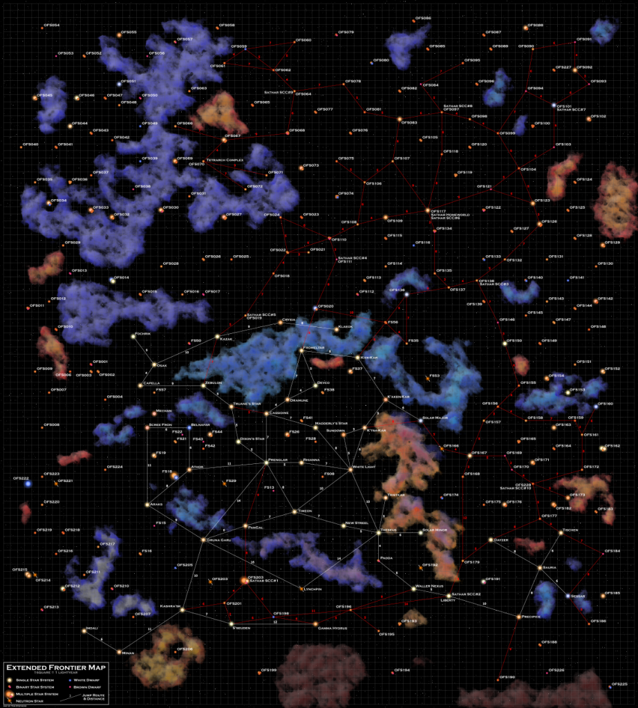
As you can see, most of the sathar systems are up and to the right of the Frontier. This is the their main population center. The tendrils that surround the Frontier tend to be more outposts and travel lanes than population centers.
In addition to the jump routes marked in red, it is assumed that the sathar know all the UPF routes marked in black as well.
The routes don’t extend to the left side of the map as the sathar stopped their expansion in that direction after encountering the Rim. They were also stopped by that big nebula in the upper left. I have plans for some of the star systems up in that area on the far side of the nebula.
I consider the jump routes along the bottom of the map, from Saurian space, past Liberty, into S’esseu space, and then up to Prenglar to be newly explored routes. In fact, in the current version of my background material, the starship construction center just south of PanGal, labeled SCC#1, is still under construction and hasn’t even started producing ships yet in my timeline project.
When I first made this map back in the 80’s, I didn’t have Zeb’s Guide and obviously none of the fan material existed so this region of space looked a little different on my original map (I should probably scan that in and post it for reference). But the idea was that these routes were established to give the sathar the jump route right into Prenglar in the Second Sathar War game in the Knight Hawks Campaign book allowing them to strike at the heart of the Frontier. In creating this map, I modified my original concept to work through these modified regions of space. It also provides an opportunity for interdiction as the UPF could potentially cut off some of the Sathar routes.
Starship Construction Centers
The numbering on the starship construction centers may seem a little odd and requires a little bit of explanation. I originally built this map for two purposes. The first was to give me a more strategic level view to write a Second Sathar War timeline, taking into account sathar ship production as well as the UPF ship production. I wanted to see how the balance of forces would work if you stuck to the rules on ship construction. This is now being realized in my timeline project.
The other was to provide a larger Frontier region for a big exploration campaign inspired by the Beyond the Frontier series of adventures (SFKH 2-4) where the PCs would explore out from Truane’s Star upward on the map. I have had the beginnings of that campaign in a notebook for literally decades. Maybe it’s time to dust it off and use it for material here on the blog.
It’s the former purpose that resulted in the numbering of the starship construction centers. I originally had the ones labeled 1-5 dedicated to the Second Sathar War effort. They were strictly producing military vessels with which the sathar would be attacking the Frontier. And I just started at the one connected to the Prenglar jump route and numbered them counter-clockwise.
SCCs number 6-9 were added in to provide “civilian” ship construction for the sathar population and exploration away from the Frontier. They are not labeled on my original map but were added in as part of this project. The final SCC, #10, was added as part of my timeline project to provide the production capacity for the Sathar offensive against the Saurians. I’ll probably do another post about the production capabilities of all these construction centers at some point in the future.
The Sathar Homeworld
The sathar homeworld is labeld on my original map. I had always envisioned it as a slightly cooler star than the sun with their home planet close relatively close in and warm and muggy. As such, I’ve given it a K4 spectral type on the map. Someday I might actually design and write up the system.
The Final Color Map
Now that we have the background information covered and everything else in place, it was time to make the final color version of the map.
This was done in two steps. First, I made a separate data file that had all the star systems again but instead of the jump routes known to the UPF, it contained the jump routes known only to the sathar. Using this, I generated a new map.
Since the map is generated with the jump routes on different layers, the second step was to just open the new map, and copy everything off the jumps route layer, open the Player’s map, create a new layer for the sathar jumps, and paste them in. I then had to adjust the position of all the features after pasting them in but that was just a matter of looking up the position in the original image and entering that in to the final image.
Of course, it really wasn’t that simple. The last step in adding the jumps was to adjust the color. The program makes all jumps in white. I simply changed the color to red in the final map. But that does give me an idea for an enhancement in the program, namely allowing the user to specify the link color.
The next step was to add the sathar specific labels. To do this I created a second names layer that I could add in the labels for the sathar homeworld, the starship construction centers, and the Tetrarch complex. Since the sathar jumps and labels are on separate layers, I can turn them on and off as need to make a player or referee version of the map as needed.
The final step was simply clean up. I went through the entire map and moved star labels and jump route distance labels in order to have the map as clean and clear as possible and fix and small issues the program has in drawing the labels. This is where I discovered the errors in the original version of the Player’s map and fixed them. And since the sathar names and jumps were on separate levels in the image, it was easy to re-export that map.
And that was it. The map is now done. (Unless I find some more typos as I start using it.) Here it is in all it’s glory.

The Code
Again, if you want to play with the code and make your own maps, it is written in Python and you can grab it from my GitHub repository. I’m going to continue to work on this code. This will be to add in the remaining features it’s lacking to make it more user friendly such as command-line options, the jump route colors, and creation of nebula, but those will fall under a different article title going forward. If I get really ambitious, I might even add in a GUI to make it a windowed program instead of a command line one. We’ll see. I’m curious how much interest there would be in that project.
Final Thoughts
This has been a fun project. I’ve really enjoyed doing it. As you can probably tell by the number of posts I’ve made. And I love the look of the final map. If you see any errors, feel free to let me know and I can update the map to correct them.
I think if I was doing this again, I would make the map dimensions a little different. This map was original made by taping together six sheets of graph paper (landscape orientation). while that ended up with a nearly square work area, it wasn’t quite. The map is 90 ly wide by 100 ly tall. If I were to do it again, I’d make it either perfectly square, or conform to a more standard aspect ratio.
I’m also curious if anyone would be interested in a printed, poster sized version of the map. 24×27 inches. This is actually what prompted my thoughts on the dimensions. As a purely digital product, the aspect ratio doesn’t matter. But when you try to print it, you start to run into problems. I’ve been looking at possible printing options, and while most of them want you to use a standard aspect ratio (16×24, 24×36, 12×18, or square), I have found a few that would let me print it to exact size. Final costs would be in the $15-$25 dollar range for the 24×27 inch one. If that is something that would interest you, let me know in the comments. I might do this as a small Kickstarter for those that are interested.
And that wraps up the the Extended Frontier Map project. Let me know your thoughts, ideas, and any remaining questions you have about the project and let me know if you’d like to see more things like this in the future.
I have certainly fallen behind on what you have been posting! Great work. I’m tempted by a poster, probably 50% chance I would go for one. (No where to put one at the moment, but…) Might have more questions later, but the one that strkes me here (other than my FB comment) is what is the difference between the colors of the nebulas? i.e. the shades of blues and reds, or are they just for artistic sake?
Minor thing: Solar Minor had its population deport to Sathar Outpost (1 or 2- I would have to check Zebs Guide) during the 2nd Sathar War. Wondering what the likely path that would have been, ie which jump routes they would have used without undo exposure to their ships on jump routes known to Space Fleet?
Ebony Eyes Jump Route? The sathar know it and it takes them into the heart of the Cassidine/Vrusk colonies loop of jump routes. It would explain the sathar “start circles” in that region of the map rather than have so many routes going through nebulae. There is some cannon statements about difficulty plotting routes through nebula, if I remember correctly.